Ok...1st things first. We have a SLIGHT chance of Severe Thunderstorms just hours before accumulating snow and the potential for a Major Winter Storm by week's end.
There are going to be 2 storms this week. One on Tuesday / Tuesday Night and the other on Thursday Night/Friday. The 2nd storm is the one with the Greatest Potential and the one we will be tracking throughout the week.
I'm going to post the computer model runs so you can watch it along with me. SEE IMAGE AT BOTTOM OF POST.
STORM 1 - "THE SLEEPER"
Here's what to expect...
- Tuesday will be Warm, Windy and Rainy.
- Rain should move in by rush hour and get heavier as the day wears on. Storms will be around in the afternoon with the threat of Severe Thunderstorms out ahead of a Cold Front. (Relax 'ligtnin' it should only be strong winds that makes them Severe)
- The Cold Front will be strong and rush in Very cold air around 10pm. That will quickly change the Rain over to Snow and it will be HEAVY!
- The snow will go on for a few hours but should wrap up before the morning Rush hour.
We will call this one the "sleeper" b/c it will be rain and be stormy on Tuesday and quickly switch to snow Tuesday Night catching everyone by surprise.
Eventhough a lot models want to put 3"-4" of snow in here by Wed Morning...I think that's a bit overdone. At this point, the cold air is too far behind the rain. Maybe a dusting(+) is all we will muster from this one.
STORM 2 - "EXCITEMENT"
Click on the picture below to zoom in.

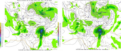
This is a picture of Friday morning according to the Weather Models. The picture on the left was created late afternoon on Monday by the computer models and the right was done early morning Tuesday. We will get another update Late this afternoon.
We are watching the Dark Blue Line (that zig zags through cincy) to stay SOUTH of Cincy and the "L" to be in KY or South East Ohio. That will bring the Heaviest Snow to Cincy and everyone gets a Snow-day.
To give everyone an Idea as to what's at stake here. The Snow in Cincy according to this map would be only about 1"-2" and nearly an inch of Rain. Indianapolis on the other hand is painted in nearly a FOOT of snow from this storm...as it stands now!
More to come....
2 comments:
I concur with the sleeper storm. While it may snow around 10pm this evening, the ground will be wet from the rain. My guess would be .5" to 1.5"(in extreme cases) since the ground will be slightly warm.
Alvin
It will be interesting to see how right you will be. Things are cool here in Florida but warming up.
Post a Comment