Wednesday, January 30, 2008

TRACKING THE STORM

UPDATE AS OF 7AM

Take "50 West"
Overnight the Storm took the 50 mile further West Track. Most of the Freezing Rain and Sleet that Fell overnight has melted, so the commute is should be just wet.

All of the area's Winter Storm Warnings have been dropped. The "Saving Grace" Theory that I had below appears to have panned out.

STORM CHASER

Watch the Transition back to snow in the morning!


UPDATE AS OF 7AM

MY CRACK....AT IT
This looks to be setting up more like an ICE & RAIN Event. You will still see snow on Friday, but the primary precip type will be Freezing Rain/Sleet/ and Rain. Snowfall will be kept at a minimum with this type of set up and track.

  • Near 8pm Thurs - Sleet and Light Snow moves in

  • Near 10pm Thurs - Changes to Sleet and freezing rain

  • Near Dawn on Friday - Rain
  • Near Noon Friday - Change Back to Snow

  • Beween 5pm and 10pm snow showers wind down


We may see some snow overnight but the primary event will be sleet, rain and freezing rain. Up to .10"-.25" of ICE on top of it. The Backside of the storm should go through after Rush hour leaving us with some accumulating snow. We may still see up to 1" accumulation but it appears the dry slot will move over Cincy as the center of the storm moves up through IN. You will see it on the Radar.

The Saving Grace in all of this is that the plain Rain may move in just after Dawn. This may help with the road treatment!


Check back frequently as updates will continue to track this throughout the night/day. REFRESH the page when you come back to get the latest update!

Monday, January 28, 2008

ACTIVE WEEK PART II

HOW THIS IS GOING TO WORK
Ok...1st things first. We have a SLIGHT chance of Severe Thunderstorms just hours before accumulating snow and the potential for a Major Winter Storm by week's end.

There are going to be 2 storms this week. One on Tuesday / Tuesday Night and the other on Thursday Night/Friday. The 2nd storm is the one with the Greatest Potential and the one we will be tracking throughout the week.

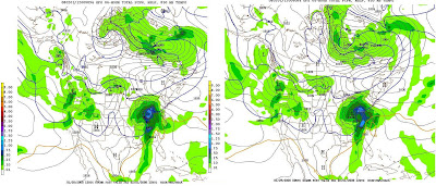
I'm going to post the computer model runs so you can watch it along with me. SEE IMAGE AT BOTTOM OF POST.


STORM 1 - "THE SLEEPER"

Here's what to expect...


  • Tuesday will be Warm, Windy and Rainy.

  • Rain should move in by rush hour and get heavier as the day wears on. Storms will be around in the afternoon with the threat of Severe Thunderstorms out ahead of a Cold Front. (Relax 'ligtnin' it should only be strong winds that makes them Severe)


  • The Cold Front will be strong and rush in Very cold air around 10pm. That will quickly change the Rain over to Snow and it will be HEAVY!


  • The snow will go on for a few hours but should wrap up before the morning Rush hour.

We will call this one the "sleeper" b/c it will be rain and be stormy on Tuesday and quickly switch to snow Tuesday Night catching everyone by surprise.


Eventhough a lot models want to put 3"-4" of snow in here by Wed Morning...I think that's a bit overdone. At this point, the cold air is too far behind the rain. Maybe a dusting(+) is all we will muster from this one.


STORM 2 - "EXCITEMENT"


Click on the picture below to zoom in.


This is a picture of Friday morning according to the Weather Models. The picture on the left was created late afternoon on Monday by the computer models and the right was done early morning Tuesday. We will get another update Late this afternoon.


We are watching the Dark Blue Line (that zig zags through cincy) to stay SOUTH of Cincy and the "L" to be in KY or South East Ohio. That will bring the Heaviest Snow to Cincy and everyone gets a Snow-day.


To give everyone an Idea as to what's at stake here. The Snow in Cincy according to this map would be only about 1"-2" and nearly an inch of Rain. Indianapolis on the other hand is painted in nearly a FOOT of snow from this storm...as it stands now!


More to come....

ACTIVE WEEK

TRUE "NAILBITER" STORM

OH BOY...THIS ONE IS GOING TO BE CLOSE! I mentioned it late last week that a POTENTIAL WINTERSTORM was showing up on the computer model maps for Friday. Well...It is still there today.

This would be a Thursday/Friday Event, but we have to get there first, and as of right now it looks to be SNOW, then MIX, then Rain, then Back to HEAVY SNOW with accumulations.

Tuesday looks to be stormy here and Warm, with a sharp cold front in the evening that will leave behind some minor accumulations of snow as it ends.

The path of this Friday storm is yet again right over Cincy. A shift of 100 miles to our East and this would be an all Snow Event with Major Accumulations. In fact, there are areas just to our West that are currently painted in 8-10" for Friday.

I am going to do somthing different. Tonight I will post the Computer Model maps, along with a preliminary snowfall map that will show the heaviest accumulations. You can watch the trends along with me. After all, this is Weather Logic and You should know what to expect!

Wednesday, January 23, 2008

CHANGES ARE A COMING...

BIG CHANGES COMING!

Saturday looks to have a few snow showers around in the morning. In fact they will roll in after midnight Friday, but shouldn't amount to much in accumulation

Temperatures will begin to warm up Sat afternoon and even more on Sunday. We will warm into the 50's on Monday out ahead of a pretty big rain maker for Tuesday. Cold air will wrap around the Tuesday storm and likely end the rain as Snow. This storm looks to be setting the stage for what could be a Major Winter Storm next Friday.

A GIANT STORM
This storm has now been on the computer models for over 10 days and Cincinnati is in the "Sweet Spot" right now for a Major accumulation and "Snow Day" next Friday. Tell the kids not to get excited just yet...We need to get inside 4 days with the storm still on the maps to have much certainty. None the less...it definitely appears a storm is coming! I'll have a picture of it late this weekend and we'll track it next week...if it stays in the forecast!


INTERACTIVE WEATHER


Take a look at the interactive weather forecaster. This will be on the page when there is a "lull" in the action for Cincinnati. There is a weekly forecast as well as hour by hour. SIMPLY MOUSE OVER YOUR AREA AND CHECK THE BOTTOM HALF FOR YOUR HOURLY FORECAST. I will be back with my forecasts and weather commentary when there is a threat for an accumulating snow or severe weather in the area.


Sunday, January 20, 2008

Finally...More Than Just COLD

LET THE GOOD 'TYNES' ROLL!!!


AP Photo/David J. Phillip

First...before we get to the weather...Those of you that know me well, know that I am an avid NY GIANTS and AUBURN Fan. Since the GIANTS are made up of AUBURN players, who would have expected anything less than a close, hard fought game that keeps you interested until the end.

Now, the GIANTS are on their way to the Superbowl when only 1 analyst has picked them to win in any of their post season games! Just goes to show what Analyst know... WAR DAMN EAGLE / LET'S GO GIANTS!!!


UPDATE

The Snow arrived a little earlier than expected but has brought the same totals we were expecting for the day. The accumulating snow for the day is finished and we now turn our attention to Thursday morning.

Snow will be flying again come late Wednesday night and into Rush Hour Thursday, and all indications are that this storm will put down about the same amount of snow. We'll watch it through tomorrow and I'll keep you updated.

SNOW..BUT NOT A BIG DEAL TUESDAY - A Clipper System looks to bring up to an inch of snow on Tuesday to the Ohio Valley. At this time, it looks to start near rush hour or just after on Tuesday and go until midnight. We should have Snow Showers around for most of the day and it may add up to around an inch to an inch and a half. Should be a nice covering but not much more than that.


INTERACTIVE WEATHER


Take a look at the interactive weather forecaster. This will be on the page when there is a "lull" in the action for Cincinnati. There is a weekly forecast as well as hour by hour. SIMPLY MOUSE OVER YOUR AREA AND CHECK THE BOTTOM HALF FOR YOUR HOURLY FORECAST. I will be back with my forecasts and weather commentary when there is a threat for an accumulating snow or severe weather in the area.


ARCTIC WEEKEND

NASTY COLD has set up for the weekend. But it should be short lived. Highs on Saturday will come early be in the low 20's in the morning. Then Temperatures will FALL in the afternoon if you can believe that! We will be near ZERO Sat night and warm to a balmy 19 on Sunday.


Wednesday, January 16, 2008

FREQUENT SMALL STORMS

"NO SHIFT FOR YOU"

I suppose you will need to be a Seinfeld Fan and read the previous post for this to make much sense.

The bottom line on Thursday's storm is that the Shift we needed does not look likely and we will be caught in the middle of 2 stronger storms.

BUT...that does not mean the ride in on Thursday morning will be easy. Here's what we should expect

  • SNOW and some FREEZING RAIN will come in Wed night and for the commute on Thursday morning.

  • We may see upwards of 1/2" - 1" before it switches over to rain in the afternoon then back to snow before ending.

  • Snow again late Thurs Night into Friday morning making for another "FUN" rush hour.

Neither of these two storms looks "Exciting" to me. Not even enough to warrant a snowfall map, however they do bring the possibility of a SURPRISE given how cold it is. We do have 2 more computer runs to watch this event for any changes.

ARCTICWEEKEND

There will be snow showers around Thursday, Friday, and Saturday and given how COLD it is going to be, they will stick around and may pile up over time. Highs on Saturday will be in the Teens. That will come in the morning, then Temperatures will FALL in the afternoon if you can believe that! We will be near ZERO Sat night and warm to a balmy 19 on Sunday.

Don't be surprised to have a few inches of snow around by Sunday that has slowly accumulated from these (dare i call them) storms. Hopefully enough to grab a sled if you feel like braving the Arctic Tundra that will be around here.


FLORIDA FOLKS

You should bet getting the Heavy Rain and liquid from the sky when ours falls as solid on Thursday. No Severe Weather Expected.

Sunday, January 13, 2008

AND SO IT BEGINS...

First...Watch the Ice in the morning. Freezing rain and snow showers around overnight should make things slick. ODOT is out treating.

WATCHING THURSDAY


This is a picture of one of the computer models for Thursday's Storm. The "L" hugging the Virginia Beach...That's your Bogey. "L" over central Virgina = 6"-8" of snow here, Out over the Ocean = No Snow here, as it stands now 2"-4" here.

As stated Friday, Sunday flirted with freezing all day with some rain, some mix, and some flurries. The snow showers are around and look to stick around through Tuesday. It will start to get downright cold and set-up for a Thursday Winter Storm. And looking long term, there are 3-4 chances for accumulating snows over the next 2 weeks.

As it stands now the storm is still hugging the East coast and we would stand to only get a few inches from it. Early indications are 2"-4". A slight shift in the storm of 100 miles to the West would bring 6"-8" to cincy. (Not unheard of given the storm hasn't formed yet).

Then it should get Nasty Cold around here for the weekend. Highs in the upper teens and low 20s' with lows in the single digits. So go get the coat, you'll need one for the weekend.


Updates to come as we learn more this week about the possibility of a Winter Storm.

Friday, January 11, 2008

CHANGES...

A NEW MILITARY "WEAPON"


Who says it doesn't snow in the desert? This is a picture from Friday morning where it snowed in Baghdad. 1st Time in 100 years!!!!!!


Even though it's not directly related to weather in your backyard, extreme weather happening elsewhere is bound to effect you sooner or later. Just look at the record snows and cold in California last week...THAT SAME STORM PRODUCED RECORD HIGHS HERE IN CINCY.


A similar situation is unfolding with this storm in the middle east. As these storms rotate around the globe, they will eventually make it to your backyard...and Next Week looks very Active around here!


COLD AND SNOW RETURN

A cold and snowy pattern is setting up for the Ohio Valley, and it all starts this on Sunday the 13th and will last for then next two weeks. This will not be a constant snow event, but we will be hit with a storm for 1-2 days, then have 1 day off, then hit for 1-2 days, and 1 day off. (queue the music from Groundhog day)

We will first be hit with a series of Alberta Clipper systems. For the Rookies out there...These are usually weak storms that drop down out of Canada that bring much colder temperatures and some snow with them. Typically they are moisture starved, but a few can surprise you, and bring a few inches of snow.

For Sunday, expect temperatures to flirt with freezing, and as it does we will see snow showers, then rain showers and then snow showers again. Problem is that most of the cold air looks to be moving in for Sunday night and into Monday just as we head back to work and school. If it looks like we will get a few inches, I'll put an update out on Sunday.


SOMETHING TO WATCH

A clipper is a clipper and usually just nuisance snows, but a Winter Storm can bring significant snows and hazardous weather with it. THERE IS STILL A POTENTIAL FOR A PRETTY SIZABLE STORM AROUND THE END OF NEXT WEEK. One that would warrant WATCHES AND WARNINGS! As it stands now we need only a 100 mile shift in the storm for Cincinnati to get the "Best" of it.

STAY CLOSE AND I'll POST UPDATES LATER THIS WEEKEND!

Wednesday, January 9, 2008

STILL WEATHER RELATED...

WAIT...DID YOU FEEL THAT? CLICK HERE FOR INTERACTIVE MAP

What you didn't notice it? Ohio had and earthquake Tuesday night! It was centered under lake Erie and was a 3.1. Everyone can relax...I'm pretty certain that there will not be any Tsunami's on the lake this week.


WORDS TO LIVE BY
Funny how nature will give you signs of what's to come. Just have to know what to look for. Here are a few things to keep in mind this week and throughout the rest of the month:

  • "Always expect a thaw in January."
  • "Fog in January brings a wet spring."
  • "He who drops a coat on a winter day, will gladly put it on in may"
  • "If on January 12th the Sun shine, it predicts much wind."


WHERE DID MY GRILL GO?

Anyone notice the 50-60 MPH winds that went through here last night? It had to be something special to take my 125 lb grill and blow it off it's stand and into the yard!

Anyway...Thursday looks to be wet again in the evening and overnight but not as much wind. The weekend may have a few snow showers around but nothing that looks like it will accumulate.

Early next week STILL holds the promise of a storm that may bring accumulating snow. Still plenty of time to watch and I'll keep you posted.

Thursday, January 3, 2008

Some Words of Wisdom

RECORDS

We went from 7 on Wednesday to 70 on Monday. So what gives? Many of you may have heard of the Record Storms hitting California this week. They are bringing 10' (Yes, FEET) of snow to that area. Anytime there is record breaking weather taking place, you can almost bet it's going to effect the weather elsewhere. So without going into too much weather jargon, and exposing my true "Weather -wise" side, just know that those storms are crossing the country and are powerful. They are pulling up warm gulf air and thus you have your 70's. Don't be surprised if we set a record High in Cincinnati on monday. We should get above 70 and the record is 69!


For those interested in 10' of snow:


Words To Live By

Funny how nature will give you signs of what's to come. Just have to know what to look for. Here are a few things to keep in mind this week and throughout the rest of the month:

  • "Always expect a thaw in January."

  • "Fog in January brings a wet spring."

  • "He who drops a coat on a winter day, will gladly put it on in may"

  • "If on January 12th the Sun shine, it predicts much wind."


JANUARY THUNDERSTORMS?

Rare, but they will be here tomorrow. This Monster storm from California that is generating all this "Heat" will come out of the Rockies on Tuesday and give us Thunderstorms and even the possibility of Severe Weather. Expect mainly strong winds and possibly some hail. (Not the right set up for Tornados).

Florida Fans...This storm will stay to your north and the Cold front won't make it to Orlando. So you are stuck in the 70s for a while. (Boo Hoo)

Take a Look:

SNOW'S BACK

Now you know 70's are not going to hold in Jan in Cincinnati. SNOW is back in the forecast for the weekend. Right now, it looks to be minor, but a small shift in an East Coast Storm on Saturday could spell for a NASTY Weekend. I'll have updates as the week goes on.

THE COMPARISON

IS THAT SNOW OR DANDRUF?

Florida Snow:


This is a picture from Daytona Beach on Thursday morning of snow flurries that fell just inland. Kind of looks the same as Ohio Snow, just sandier!


Cincinnati Snow:


MID JAN STORM- STILL THERE


There's a little excitement on the horizon- A sizable Winter Storm has shown up on the computer models for the last 3 4 days. At this point it looks to be around the 13th - 15th. We'll keep watching and I'll keep you posted.