Saturday, May 31, 2008

PUT YOUR GUARD DOWN

MUCH QUIETER
Finally a little peace and quiet around here. It's been borderline CRAZY around here for the last few days. Now we can relax and enjoy Summer that has quickly made its presence known.


WEATHER FORECASTER


Take a look at the interactive weather forecaster. This will be on the page when there is a "lull" in the action for Cincinnati. There is a weekly forecast as well as hour by hour. I will be back with my forecasts and weather commentary when there is a threat for an accumulating snow or severe weather in the area.

Tuesday, May 27, 2008

The Countdown Is On

Severe Friday and Saturday

Things are shaping up for an active start to the weekend. Strong storms are forecasted to develop late tonight into tomorrow morning as a low pressure system moves in from the west.

A few of these storms could be severe. The National Weather Service is forecasting the primary threat of these storms to be strong winds and heavy rains. We do not expect to get any tornados like the had out west over the last few days. However, we cannot completely rule out the possibility of a tornado. (Might help get rid of those bugs.... or the shed you dont want anymore. Or better yet, you could get your neighbor's shed in your backyard)

The map below will tell you any watches or warnings that may be present. Refresh often for the latest radar and warning map.


WATCH THE STORMS MOVE IN


Ladies and Gentlmen, Say Goodbye to Alma


Tropical Storm Alma formed over the far eastern portion of the Pacific Ocean near Central America a few days ago and now she is on her way out. However, the main threat for people there will continue to be flash flooding. Current winds have subsided to 25mph.

Below is a map showing where she formed and her path.


Storm Is Forming!

The Atlantic Hurricane season kicks off on Sunday and right on time. There are more and more signs of a Tropical Depression forming near Cancun late next week (6/5 or so). Early projections are for it to become a Tropical Storm and move into the Gulf of Mexico and run up the West side of Florida. So why would Cincinnatian's care...The projected path brings the heavy rains this way...which is the last thing we need.


Below is how one of the computer model's of how next Saturday (6/7) will play out. Kind of hard to miss!!!


Plenty can still change. We'll be watching the tropics all week, especially for our friends in Florida! Keep checking back for new tools, maps and updates related to Hurricane Season.


WEATHER FORECASTER


Take a look at the interactive weather forecaster. This will be on the page when there is a "lull" in the action for Cincinnati. There is a weekly forecast as well as hour by hour. I will be back with my forecasts and weather commentary when there is a threat for an accumulating snow or severe weather in the area

Monday, May 19, 2008

TALE OF 2 WEEKENDS

CICADA UPDATE
(Emergence at 65 Degrees)

5/23 = 63.5 Degrees
5/22 = 62.5 Degrees
5/21 = 62.5 Degrees

Well Folks, this looks like the weekend that they will begin to come out of the ground in the millions. With the ground temperatures just 1.5 degrees below the critical 65, and the warm weekend expected. They should be there just in time for your Memorial Day Bar-B-Q!

WEEKEND WEATHER

Weather-wise...this should be a PERFECT Memorial Day Weekend. Highs on Saturday and Sunday are expected to be in the Mid to upper 70's and Monday in the mid 80's!!!!! No rain expected until early Tuesday morning! With weather like that, All 3 days are this week's "Pick Day".

So, quoting one of the states best fisherman who has his own "Corner" on this website..."Son, GET THE NET" as this weekend will be perfect for fishing or backyard cook outs with the Cicadas! Nets Required for both!

WEATHER FORECASTER


Take a look at the interactive weather forecaster. This will be on the page when there is a "lull" in the action for Cincinnati. There is a weekly forecast as well as hour by hour. I will be back with my forecasts and weather commentary when there is a threat for an accumulating snow or severe weather in the area

Friday, May 16, 2008

Hurricane countdown


RUN-AWAY WEEKEND

WEATHER FORECASTER


Take a look at the interactive weather forecaster. This will be on the page when there is a "lull" in the action for Cincinnati. There is a weekly forecast as well as hour by hour. I will be back with my forecasts and weather commentary when there is a threat for an accumulating snow or severe weather in the area

Monday, May 12, 2008

HERE THEY COME!!!

"THEY'RE BAA-AA-AK"

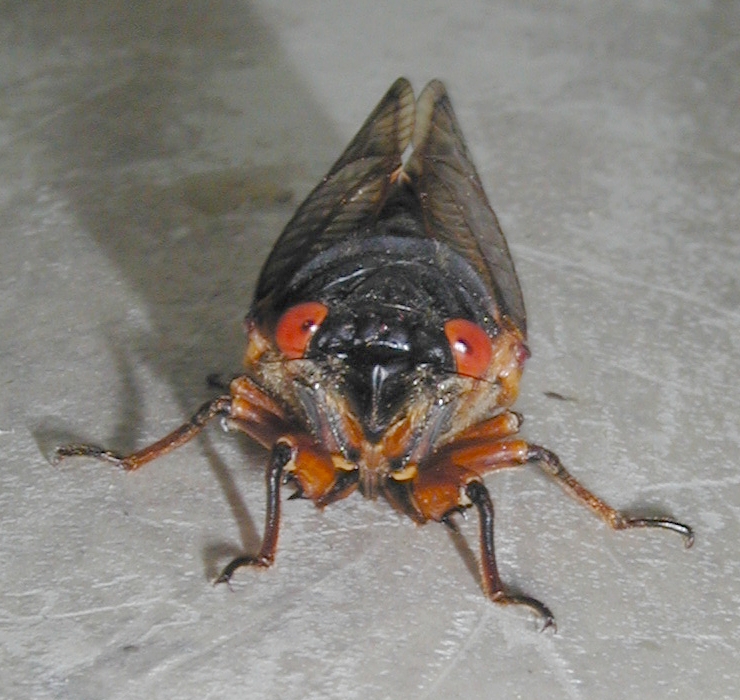
UPDATE SOIL TEMPERATURE: (65 Degrees = Emergence)

5/15 = 61.2 Degrees

5/14 = 61 Degrees

5/13= 62 Degrees

5/12= 61 Degrees

Good Thursday Morning! Who's tired of being stared at by the bug? We've had the "bug page" up for over a week now and we've hit a cold spell. The cicada in the picture is getting tired of staring at you!!!

Cool, rainy days are keeping the soil temperature in the low 60's ....Right on the brink of emergence for the Brood XIV Cicada in Cincinnati. Looking over the forecast for the rest of the week and into the weekend, we will still see cool days and showers. In fact, we won't see the air temperature reach the 70's until early next week.

This will be the last post for the 'bugs' until we get closer to the emergence temperature. Friday will have "Race Weather". Not sure what race is around??? STAY TUNED.


WEATHER FORECASTER


Take a look at the interactive weather forecaster. This will be on the page when there is a "lull" in the action for Cincinnati. There is a weekly forecast as well as hour by hour. I will be back with my forecasts and weather commentary when there is a threat for an accumulating snow or severe weather in the area

Friday, May 9, 2008

OH NO....NOT AGAIN!

"THEY'RE BAA-AA-AK"

Yes...It's the flying bug that strikes the fear of God in Rodger Turner and so many around the tri-state. The Cicada is back and coming to a home near you in a matter of days.

So why is this on the weather blog for Cincinnati you ask...Well this particular breed of cicada is called the Brood XIV. Their parents were here in 1991 and these little guys have been growing deep in the ground ever since. They will come up once the soil temperature reaches 65 degrees! As of Friday morning, it is 63!

So, if you are like the Master Marketing Mind of Jeff Andrews (boss), and found a few around the yard over the weekend, just know that millions of their brothers and sisters are about the follow! Find your house on the map below and determine if you will be included in this years Swarm!


Weekend Weather

Friday- Cloudy with rain moving in during the evening. Highs in 60s. Saturday- Pick Day! Becoming mostly sunny with highs in upper 60's. Sunday- Mother's Day! (Better go get something). Highs in 60's with plenty of RAIN! Sorry mom!


HAPPY BIRTHDAY BUSCHMANN!!!

Buschmann, you should know by now that no good birthday goes un-noticed on Weather Logic!


WEATHER FORECASTER


Take a look at the interactive weather forecaster. This will be on the page when there is a "lull" in the action for Cincinnati. There is a weekly forecast as well as hour by hour. I will be back with my forecasts and weather commentary when there is a threat for an accumulating snow or severe weather in the area

Sunday, May 4, 2008

Nice Spring Week

After a salvageable Sunday...could this be the 1st weekend in over a month that the rain stays away?

The week looks pretty nice with highs in the 70's and only a threat of rain on Wed and Thursday. We'll keep watching the weekend and an update on an unwelcome visitor that will be coming to your house within the next 2 weeks....due to the Weather!?!?!

More to come!


WEATHER FORECASTER


Take a look at the interactive weather forecaster. This will be on the page when there is a "lull" in the action for Cincinnati. There is a weekly forecast as well as hour by hour. I will be back with my forecasts and weather commentary when there is a threat for an accumulating snow or severe weather in the area


Thursday, May 1, 2008

WEEKEND WONDER

Weekend Weather
Seems everyone's got big plans this weekend...Garage sales, to soccer games, golf matches to horse races! It will be a hopping around the tri-state...OR WILL IT?


For the 4th weekend in a row, mother nature seems to want to try and spoil it. A strong cold front will makes its way though the area late Friday and into Saturday morning. In fact, Severe weather may be possible. We are watching that closely.


WEEKEND DETAILS
Friday: Sunny skies will cause Scattered showers and thunderstorms to form out ahead of the cold front. They should arrive by late afternoon. The Strong front approaches overnight friday, we'll see a line of Thunderstorms move through near dawn on Saturday. This would be our best bet for severe weather. Isler, you should only be dodging scattered showers friday evening.

SATURDAY: The cold front should move through by noon on Saturday. We should have a break for most of the afternoon, but another round of showers look to return in the evening 4-7pm as another small line moves through before midnight. Karen...you'll be dodging lightning bolts saturday morning in Dayton.

SUNDAY: Best Bet for a 'pick day' this weekend. Highs in the 60's with a possible shower around in the morning.

WEATHER FORECASTER


Take a look at the interactive weather forecaster. This will be on the page when there is a "lull" in the action for Cincinnati. There is a weekly forecast as well as hour by hour. I will be back with my forecasts and weather commentary when there is a threat for an accumulating snow or severe weather in the area